TihioRace MTB Edition
Mountain biking
16 km, 34 km, 74 km, 108 km
About the event
Races offered by this event
You have 1 weeks to prepare
Tihiorace MTB Marathon 74km
Tihiorace MTB CUP 108km (74km + 34km)
Tihiorace MTB Full Race 34km
Tihiorace MTB Short Race 16km
Course details
Course highlights
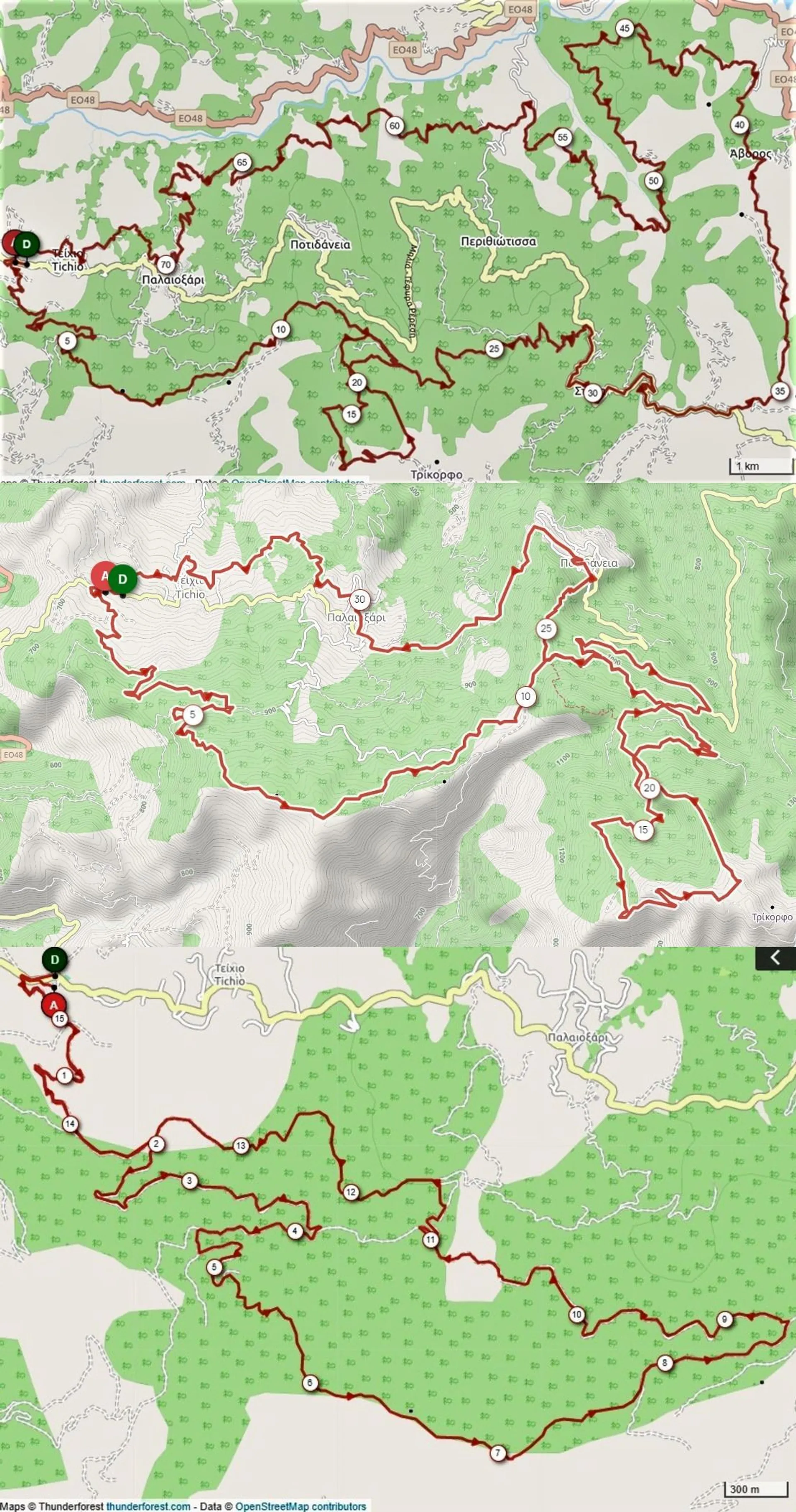
ROUTE DESCRIPTION 74km – 2,400m elevation gain Route Difficulty: MODERATE in terms of technical difficulty and MODERATE for its uphill sections (referring to the average mountain biker). A few meters after the asphalt start we enter a forest uphill of about 4km with a 6% average gradient. Then we continue on a narrower forest that has almost 1km of straight and slightly downhill section and then we start a narrower forest uphill, with an average gradient of 10% (up to 15% maximum), which you continue on a path for a total of 1.2km. There we are at 1,100m with a view up to the bridge of Antirion. Moving on the ridge, we continue the path with a downhill slope and short steep uphill sections of a few meters. Then we move on forest roads with alternating downhill and slightly uphill sections. At 12km, the second ascent begins for 7.2km through an amazing fir forest, up to the summit at Trikorfos at 1520m with a 6.2% average gradient. There we start a descent on a path, quite technical, in 2 different sections totaling 4km!!! We continue along the forest dirt road in the fir forest until the asphalt road and head towards Stylia and after the village we go down the forest road to Avoro. We pass through the village and move towards the asphalt road that descends from Perithiotisa. We stay for 1km on the asphalt and enter the dirt road to Paleoxari where the third climb of 4.5km follows with an average gradient of 7% that ends in the village. We continue with forest and path with alternating uphill and downhill sections until the finish. ROUTE DESCRIPTION 34km – 1,220m elevation gain Moving on the ridge, we continue the path with a downhill slope and short steep uphill sections of a few meters. Then we move on forest roads with alternating downhill and slightly uphill sections. At 12km, the second ascent begins for 7.2km through an amazing fir forest, up to the summit at Trikorfos at 1520m with a 6.2% average gradient. There we start a descent on a path, quite technical, in 4 different sections totaling 4km!!! We reach the asphalt shortly after Potidanea, where after 1.5 km of asphalt we enter an uphill forest road that leads us to the entrance of the path that ends in Potidanea. It follows 3 km of asphalt that ends in Paleoxari. We continue with a path through the village and then we enter a forest and a path with alternating uphill and downhill sections until the finish. ROUTE DESCRIPTION 16km - 520m positive elevation Route Difficulty: MODERATE in terms of technical difficulty and DEMANDING for its uphill sections (referring to the hobbyist mountain biker). A few meters after the asphalt start we enter a forest uphill of about 4km with a 6% average gradient. Then we continue on a narrower forest that has almost 1km of straight and slightly downhill section and then we start a narrower forest uphill, with an average gradient of 10% (up to 15% maximum), which you continue on a path for a total of 1.2km. There we are at 1,100m with a view up to the bridge of Antirion. Moving on the ridge, we continue the path with a downhill slope and short steep uphill sections of a few meters. The remaining kilometers to the finish are mostly downhill, on narrow or wide forest roads with small technical sections (water troughs, rolling stones, etc.). At 13 km the new path has been added where it ends in the forest that leads to the finish. General characteristics of routes: Forest roads, mostly narrow with very good terrain and paths, uphill and downhill, with good terrain, points with tight turns and technical sections.
Start address
Tichio, GreeceFinish address
Tichio, GreeceRoute map
What’s included in entry
Frequently Asked Questions
Reviews
Find hotels near TihioRace MTB Edition
Closest events
Top destinations: Mountain biking
The price shown is converted as an approximate cost in your selected currency. Exchange rates may change while completing your purchase. Always check with your issuing bank for an exact exchange rate.
© Ahotu is a World's Sports Group owned service and brand. All rights reserved.
Version: 9.2.0