TihioRace MTB Edition
Vtt
16 km, 34 km, 74 km, 108 km
À propos de l'événement
Courses proposées par cet événement
Tihiorace MTB Marathon 74km
Tihiorace MTB CUP 108km (74km + 34km)
Tihiorace MTB Full Race 34km
Tihiorace MTB Short Race 16km
Détails de la course
Points forts de la course
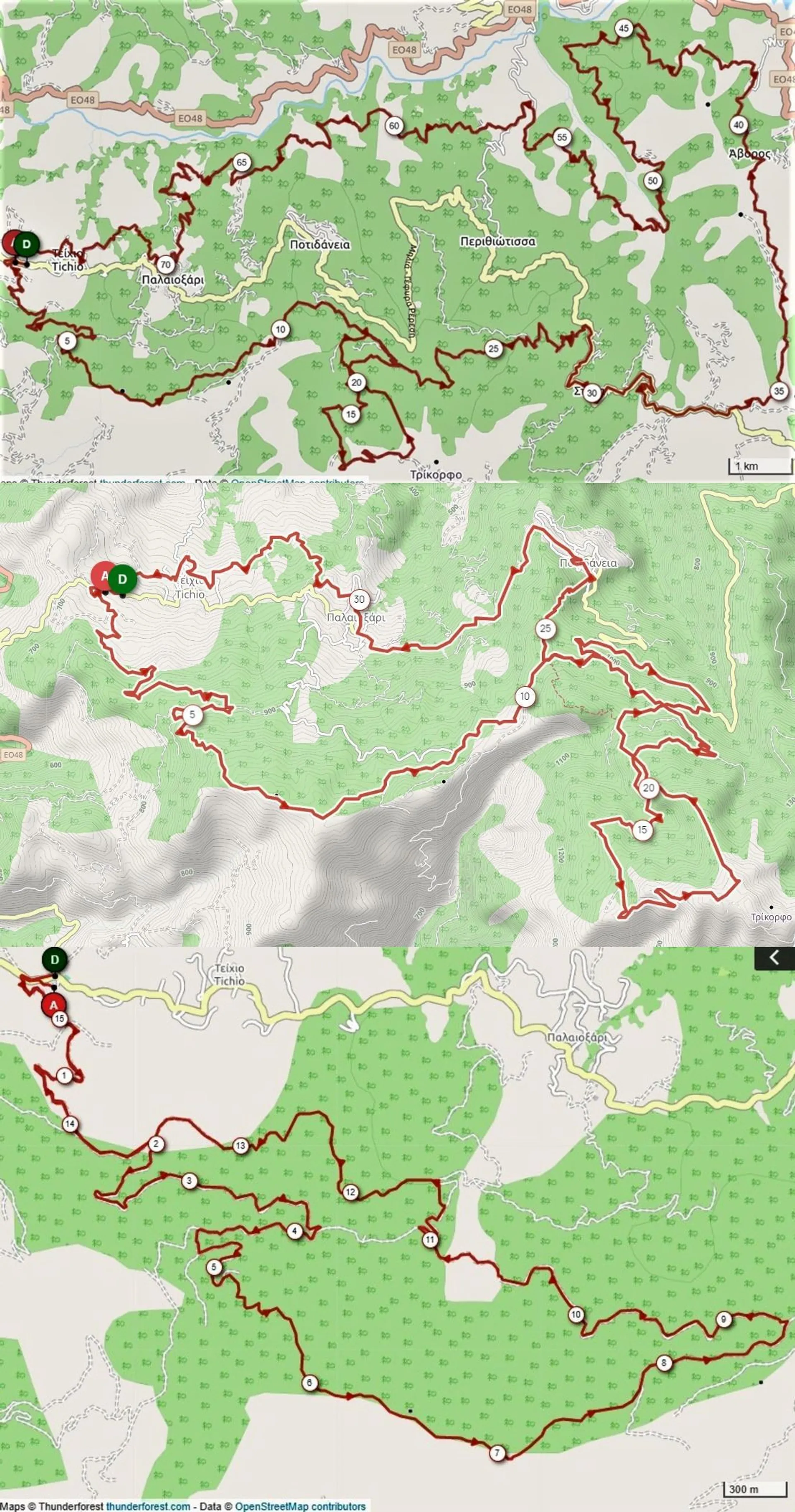
ROUTE DESCRIPTION 74km – 2,400m elevation gain Route Difficulty: MODERATE in terms of technical difficulty and MODERATE for its uphill sections (referring to the average mountain biker). A few meters after the asphalt start we enter a forest uphill of about 4km with a 6% average gradient. Then we continue on a narrower forest that has almost 1km of straight and slightly downhill section and then we start a narrower forest uphill, with an average gradient of 10% (up to 15% maximum), which you continue on a path for a total of 1.2km. There we are at 1,100m with a view up to the bridge of Antirion. Moving on the ridge, we continue the path with a downhill slope and short steep uphill sections of a few meters. Then we move on forest roads with alternating downhill and slightly uphill sections. At 12km, the second ascent begins for 7.2km through an amazing fir forest, up to the summit at Trikorfos at 1520m with a 6.2% average gradient. There we start a descent on a path, quite technical, in 2 different sections totaling 4km!!! We continue along the forest dirt road in the fir forest until the asphalt road and head towards Stylia and after the village we go down the forest road to Avoro. We pass through the village and move towards the asphalt road that descends from Perithiotisa. We stay for 1km on the asphalt and enter the dirt road to Paleoxari where the third climb of 4.5km follows with an average gradient of 7% that ends in the village. We continue with forest and path with alternating uphill and downhill sections until the finish. ROUTE DESCRIPTION 34km – 1,220m elevation gain Moving on the ridge, we continue the path with a downhill slope and short steep uphill sections of a few meters. Then we move on forest roads with alternating downhill and slightly uphill sections. At 12km, the second ascent begins for 7.2km through an amazing fir forest, up to the summit at Trikorfos at 1520m with a 6.2% average gradient. There we start a descent on a path, quite technical, in 4 different sections totaling 4km!!! We reach the asphalt shortly after Potidanea, where after 1.5 km of asphalt we enter an uphill forest road that leads us to the entrance of the path that ends in Potidanea. It follows 3 km of asphalt that ends in Paleoxari. We continue with a path through the village and then we enter a forest and a path with alternating uphill and downhill sections until the finish. ROUTE DESCRIPTION 16km - 520m positive elevation Route Difficulty: MODERATE in terms of technical difficulty and DEMANDING for its uphill sections (referring to the hobbyist mountain biker). A few meters after the asphalt start we enter a forest uphill of about 4km with a 6% average gradient. Then we continue on a narrower forest that has almost 1km of straight and slightly downhill section and then we start a narrower forest uphill, with an average gradient of 10% (up to 15% maximum), which you continue on a path for a total of 1.2km. There we are at 1,100m with a view up to the bridge of Antirion. Moving on the ridge, we continue the path with a downhill slope and short steep uphill sections of a few meters. The remaining kilometers to the finish are mostly downhill, on narrow or wide forest roads with small technical sections (water troughs, rolling stones, etc.). At 13 km the new path has been added where it ends in the forest that leads to the finish. General characteristics of routes: Forest roads, mostly narrow with very good terrain and paths, uphill and downhill, with good terrain, points with tight turns and technical sections.
Adresse de départ
Tichio, GreeceAdresse d'arrivée
Tichio, GreeceCarte de l'itinéraire
Ce qui est inclus dans l'inscription
Questions fréquemment posées
Avis
Liens officiels
Trouver des hôtels près de TihioRace MTB Edition
Nos partenaires
Le prix indiqué est converti en coût approximatif dans la devise choisie. Les taux de change peuvent changer pendant que vous effectuez votre achat. Vérifiez toujours le taux de change exact auprès de votre banque émettrice.
© Ahotu est un service et une marque appartenant à World's Sports Group. Tous les droits sont réservés.
Version : 9.10.0